

Pin Parvati Pass Trek from Kaza - 11 Days
About the Trek: The Pin Parvati Pass is a thrilling challenge for any seasoned trekker. It’s a long expedition that gives trekkers a massive dose of adventure, beauty and a sense of achievement. The exhilaration of traversing a 17,457 ft pass is an experience of a lifetime. Pin Parvati Pass trek provides the most spectacular traverses, right from the forest and verdant meadows of the Parvati Valley to the Buddhist villages in the Trans-Himalayan region of Spiti. The sharp contrast in landscapes, culture, flora and fauna will catch you off-guard. Within hours, you’ll walk from cold dry mountain desert region of Spiti to the rich biodiversity in Parvati Valley. As you climb higher to Pin Parvati Pass, the bird’s-eye view of the Parvati and Pin Valley is fantastic. Pin Parvati has a host of unique experiences to offer you: from the pulley bridge at Tunda Bhuj to marshlands of Mantalai to alpine meadows of Odi Thach, dense forests near Kheerganga and glacier near the Pass. Pin Parvati trek builds from cold dry deserts of Spiti and its unique settings to the lush, wet greenery of Parvati valley. The greenery, the flowers of Odi Thach hits you harder after days of trekking among wind-carved rock formations and glaciers. Near the end of trek, you also experience the hot water springs at Parvati Kund at Kheerganga. Words cannot describe the experience of a hot water bath here after a hard day of trekking. It is a five star sauna experience on a trek, which you seldom get on any Himalayan Trek.
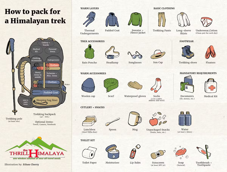
Trek at a Glance
Duration : 10 Nights & 11 Days
Grade : Moderate-Difficult
Physical Level : Expart
Season : July to October
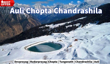
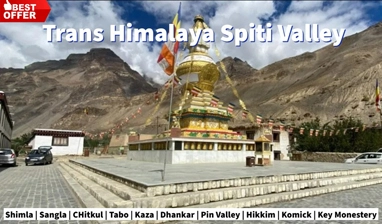
Locations : Kaza.
Highest Altitude : 17,457 ft
![]()
Day – 1 Getting to the Base Camp - Kaza. (Altitude: 12,467 ft (3,800 m)| Time taken: 10-12 hours drive)
Take an overnight bus from Delhi and reach Manali the previous day. Pick up will be arranged from Manali at 6.00 am. The Rohtang and Kunzum passes are known for their notoriously bad traffic jams, making it all the more necessary to leave by 6.00 am. Drive out of Manali, and towards Batal via Rohtang pass on the Manali-Leh Highway. The road is not too good and is bumpy all through. From Gramphu, take a diversion towards the Gramphu – Batal – Kaza road. From Batal the route winds through the real Spiti Valley. Quaint little villages, tucked away in the mountains and arid mountains dotted with green and yellow patches of peas and barley fields. The route from here is straight out of a picture postcard. You will be camping along the Spiti river in Kaza. The acclimatization process starts today.
Day – 2 Acclimatization Day at Kaza. (Altitude: 12,467 ft)
Day – 3 Drive from Kaza to Mudh village; trek from Mudh to Tiya. (Altitude: 12,283 ft (3,744 m) to 12,795 ft (3,900 m) (trek from Mudh village to Tiya) Time taken: 2 hours drive + 2-3 hours trek)
From Kaza, drive down to Mudh village which is at a lower altitude. The drive will take you about 2 hours and covers a distance of 49km. Once you reach Mudh village start trekking to Tiya. You will reach Tiya in 2-3 hours. Mudh is a picture-postcard worthy village with whitewashed houses, peas and barley terraced fields. You can find guest houses here to accommodate trekkers trekking in Pin Valley. Pin Valley is known as snow leopard and ibex country. However, chances of spotting these animals on your trek remain elusive. It is important to start for Mudh from Kaza early as streams gets swollen later in the day, making it difficult to cross. Mudh is the last village you will see on this trek until Kheerganga on the second last day. This is also the only day of luxurious trekking - a very gradually ascending walk on scree and shale surrounded by barren yet colourful mountains typical of Spiti. The trails are well-defined with minimal chances of getting lost. You will be trekking along the Pin River through the day, moving upstream. The trekking trail is at a higher level than the river, so it won't be possible for you to fill water anywhere. However, to set up camp at Tiya, descend to the river bed. You will have limited level ground that is suitable for putting up tents. Across the river is Mangrungse - which is a campsite on Pin Bhaba trek.
Day – 4 Tiya to Shia. (Altitude: 12,795 ft (3,900 m) to 14,763 ft|Time taken: 5-6 hours)
A long day for trekking with beautiful views of Spiti Valley. An early start is important to ford the multiple glacial streams today- which will leave your feet numb. A couple of these tiny streams are also drinkable. Starting on the left bank of the Pin river, the first section is an undulating walk on loose, sedimentary rocks. After this section, you descend to the river, cross it and ascend up the other side. There are a couple of tricky sections - narrow scree-laden ledges over the river that need navigating. After you've trekked some distance, the Pin Glacier becomes visible high up, in the distance. Shia is a shepherds' campsite with barely enough space for camping. You have to find space among the rocks and shale to set up camp. This is also a landslide prone area, so you have to be careful.
Day – 5 Shia to Pin Base Camp. (Altitude: 14,763 ft (4,500 m) to 15,780 ft|Time taken: 5-6 hours)
Start your day by crossing the Pin river. You will have to remove your shoes. However, this is not easy to cross barefoot as there are a lot of stones and pebbles on the river bed. If the flow is strong and not manageable, you will have to go 2 km ahead and cross it over the glacier. The ascent to Pin Base Camp will leave you breathless. It is a steep ascent of 1,700 ft. There is also a tricky section that comes midway in the ascent- a stream crossing. This stream comes from Pin glacier (we will camp close to its glacial line) and the volume of the water is high. With the stream flowing on an incline, special care has to be taken while crossing it. The flow of the water is such that you can be swept down to the valley below. The team will have to be roped up for this section. Pin Base camp is a bare, rocky moonland below the Pin glacier and 1,000 ft below the Pass. The camp is also quite windy with views of rugged mountains all around - the setting is almost like Bhagwabasa campsite on Roopkund. These are very different mountains from the ones you see in Uttarakhand or the lower Himachal.
Day – 6 Pin Base camp to Mantalai via Pin Parvati Pass. (Altitude: 15,780 ft to 17,457 ft and descend to 13,440 ft|Time taken: 12 hours
Depending on the weather, an early start for the Pass is crucial. The Pass should not be traversed after noon as the weather always deteriorates in the second half of the day. The ascent to the Pass is tough, mainly because of the of the altitude - the glacier section is on a gradual incline. There are no crevasses to worry about on Pin side of the pass. The older and originally considered Pass can be seen to the left of the ridge. The Pass used nowadays is at a higher plane, above the one at the left. The world changes at Pin Parvati Pass! The bird’s eye view of both Pin valley and Parvati Valley is one of those grand views that stay with you. It is a very pretty panorama of both the valleys with unnamed peaks populating your view. You can see Parvati South Ridge, Snow Peak, Ridge Peak, Pyramid Peak, Kullu Makalu and Bara Shigri. You might even spot Kinner Kailash and Shrikhand Mahadev, if you know what to look for. The prayer flags fluttering- on your left- adds to the atmosphere at the Pass. Enjoy the view of lofty peaks from Kinnaur, Kullu and Spiti. You can also spot the Mantalai camp, far below, from the pass. The descent to Parvati glacier is brutal - it is sharp and crevasse-ridden. The snow hides these crevasses so you have to be extremely careful. Ensure the team follows the guides' instructions as he finds the path through the glacier, and descend in a single file. The glacier tapers off and becomes wetter and muddier, transforming into a scree laden plateau. Parvati Base Camp is similar to Pin Base Camp. The weather gets very cold here and the wind chill factor is high. It is a much better option to do a longer trek to Mantalai and have a rest day. The descent to Mantalai is steep and strewn with boulders which makes it a painful affair. Depending on the season, the trail can have snow. From here, you will see breathtaking views of the Parvati valley. You will also see many endangered species of plants and flowers, especially “Losars” and the “Brahmakamals”. Following the shepherds' trail, you will cross at least 2-3 mountain slopes before you reach Mantalai. At Mantalai, you will have to cross the ice-cold river barefoot and then proceed ahead along the river. Mantalai, said to be the source of Parvati river is not a conventional lake. The boundary of the lake is ill-defined and the area surrounding it is a marsh. The first signs of vegetation start from here - you might even find shepherds and a Baba living in a rock shelter. You will be able to see Pyramid Peak from its base to top and another unnamed peak on the other side. It is by far, the most beautiful and unique campsite you have come across on this trek.
Day – 7 Rest Day at Mantalai Lake
Day – 8 Mantalai Lake to Odi Thach campsite. (Altitude: 13,440 ft to 12,517 ft|Time taken: 4 hours)
This day consists of a scenic 9 km downhill hike all the way to the famous meadows of Odi Thach. Walk ahead, along the right side of the river bank, up to a moraine-filled ridge. Once you reach the top of the ridge, you get a view of the point from where Parvati river is gushing down. You have to climb down a series of huge scattered boulders after which it levels out to a valley walk. This is an easier day compared to others as most of it is in a valley section. Follow the trail on the right side of the valley till you reach a large ridge breached from the right side from where the River Parvati rushes down towards Mantalai. After traversing the first of the series of ridges, you officially exit the Mantalai region. The route towards Odi Thach swirls towards the left side of the valley and it becomes easily the prettiest day of the trek. The flowers near Odi Thach give you slopes which are completely decked in red, blue and purple colours. It really hits you, coming from the barrenness of Spiti valley. Every 100 metres after these slopes, you will feel like camping. The swamp land - with a very peaceful Parvati river which branches out to streams - culminates into a plateau and then goes through boulders till you reach level meadow - Odi Thach. A little ahead of Odi Thach is Jwari Thach where we camp.
Day – 9 Odi Thach to Tunda Bhuj. (Altitude: 12,517 ft to 10,499 ft|Time taken: 8 hours)
A difficult day like this one would surprise you at this stage after the trek to Odi Thach. It starts out gradually over the meadows and goes lower into the valley to the Parvati river through boulder -strewn fields and streams. You will see a series of waterfalls on your right side and Parvati river flows on your left. Notice Mt Kullu Eiger in front of you to your left along with some un-named peaks and glaciers surrounding the valley. Then you descend down to Pandu Pul which is a natural natural bridge over the river formed by large, misshapen boulders. This rock section can be tricky and slippery so be careful. During rains, one can rope the entire team for safety. You will have to climb down another rock jammed on top of a tributary of Parvati the same way before you head to out to an open valley with waist high shrubs to wade through. You will have to keep your eyes glued to the terrain as you will be walking on narrow ledges over the river. The pulley that takes you to Thakur Kuan is broken so you will have to stay on the same side of the river. This trail, however, gets tricky as it is overhanging the swollen Parvati river in many places. You cannot afford to make a mistake here. If the weather is not friendly, crossing this section will become dangerous. Once the tricky patch gets over, which is the only mountainous patch for today, you will enter forest a full of rhododendrons and pine trees.Tunda Bhuj campsite is a bowl on the mountain surrounded by cliff faces, higher up from the river. There are a series of waterfalls on these beautiful cliff faces and descending into mist. The lush greenery feels luminescent after the moonlands of Spiti. Pin Parvati is an experience that grows better after each campsite – with a layers of greenery adding on and following the various moods of the Parvati river.
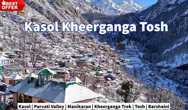
Day – 10 Tunda Bhuj to Kheerganga. (Altitude: 10,499 ft to 9,120 ft|Time taken: 4 hours)
Today’s trek to Kheerganga is a steady descent to the gorge below where Parvati River is coming down at your right side. The trail will take you through many pasture lands, inside silver birch trees. You will also notice a series of lovely waterfalls on the huge mountain walls at the right side of the trail. These waterfalls, as they cascade down jagged mountain faces dissipate as mist. It is quite a sight. Start your day by crossing the bridge over a tributary of Parvati river. An abandoned hut can be located on the left side of the trail. The trail will swirl downhill, out of the expanses of Parvati Valley to an open pasture land. The first forest section – reminiscent of pine forests on Roopkund trail will be steep. Watch your step as it can get slippery with all the mud. After 30 minutes, you enter pastures again – full of knee high bushes and boulders. On your right, you will see local shepherds living in their tents. You can buy fresh buffalo milk from there at a reasonable rate. Ahead of you is a makeshift bridge that you have to cross – the second bridge for the day. After about 25 minutes of hike from here, the trail curves towards the left. You will find a small tent with locals selling refreshments – this is the first sign of civilisation after trekking through an entirely remote region. This is the first of many dhabas you will find near Kheerganga. From the pasture land, there is a meandering descent down to forest for 30 minutes that exits into another small open pasture land. From here, you descend down to the stream and crossover the last tributary for the day over a makeshift bridge. The trail ascends from the stream for about 45-50 minutes followed by a series of gradual incline and decline towards Kheerganga. You will reach Kheerganga by 1 pm and this is, frankly, one of the shorter days of the trek. Kheerganga is your last campsite and it feels like the end of the trek. There are many cafes in Kheerganga and you are not the only one pitching a tent there. With the music playing in cafes, civilisation has creeped into this beautifully remote trek. You can also take a bath in the hot springs of Kheerganga, which is a five star sauna experience at the end of long, tough trek. It is quite a luxury after an arduous trek like Pin Parvati!
Day – 11 Kheerganga to Barshaini; depart from Barshaini. (Altitude: 9,120 ft to 7,251 ft|Time taken: 3 hours)
Trek for 7 km from Kheerganga to Barshaini. You will reach Barshaini around 11am. The trek ends at Barshaini. Indiahikes will arrange for transportation from Barshaini to Kullu. The cost of which will be additional and is to be paid to the drivers directly. It takes roughly 3 hours to reach Kullu. You can take the afternoon bus from Kullu to Delhi the same day. The trail enters a thick forest cover as you start the trek for Kheerganga. This region experiences lot of rainfall so expect the trail to be filled with excess mud on a rainy day. Since this is going to be a steep descent, remain alert as the trail can get slippery at times. It becomes a level walk after 40 minutes. Since Kheerganga is a popular trail, you will find dhabas on your way down. There will be a couple of streams running down the mountain on your right. They can be used for filling up your water bottles if needed. You will cross a makeshift bridge over River Parvati one last time today – and Parvati is a gushing, angry force now from the serenity it exuded from its source, Mantalai. Parvati River is quite the moody companion from Mantalai. Just 5 minutes ahead of the makeshift bridge is Rudranag. It is a small piece of land considered sacred, and has a temple dedicated Lord Shiva right next to it. There is a small waterfall next to it. The trail from here has its share of uphill and downhill walks and is manageable. About 30-45 minutes into the hike with Parvati river gushing below on your left side, you enter Nakthan Village. From Nakthan, the descent is steep – however, the trail is well laid, going through villages and lovely apple orchards down to an open meadow called Swagani Maidan. With a motor-able road all the way to Barshaini, very few travelers trek the old 12 km, 6 hour hike from Manikaran to Pulga which is said to be a scenic trail going beside the right bank of Parvati river, passing some small villages like Uchich village. Pulga has a Forest rest house build of pure teak wood where one can find accommodation to stay. You will reach Barshaini by 1 pm.
For Package Details, Please Call us at: (+91) 78310-50555, (+91) 98163-50555
Important Places to Visit In This Tour


Package Tour Price |
|---|
|
PRICE ON REQUEST 10 Nights & 11 Days | Ex- Kaza * Call Us for Latest Package Offers.
|


I'am Interested! Please tell me the Best Offer!!
Package Includes
- All trekking arrangements including sleeping tents on twin sharing (Alpine shape), sleeping mattresses, sleeping bags, toilet tents, dinning tent (in case of a large group), kitchen tent, English speaking mountain guide, cook, kitchen helpers, camp boys, Mules for luggage.
Package Excludes
- Any bus, air or train fare before and after the tour.
- Any Hotel accommodation before and after the trek.
- Insurance of any kind (personal, medical, accidental etc.
- Items of personal nature such as beverages, laundry, phone bill, tips etc.
- Emergency evacuation charges (if any).
- Portage at railway stations and hotels.
- Anything that is not mentioned under the “quote includes” head
- GST 5% Extra